Outputs For Your Aerial Data
Aerial Data Outputs
There are so many ways to share and use aerial data collected by AZ Drone. Some ways are more about fun presentations and marketing materials. Other output formats are all about the serious side of your business. The applications are wide open, and we'll talk about all of them on this page!
The types of outputs available will depend on the final vision you'd like to present. Job site images will fall under some categories that may be for internal use only. Other presentation formats may be intended for public consumption, and can easily be embedded on your business website. Here's a short list of formats AZ Drone can deliver:
- GeoTiffs - 2D
- Full sized JPEGS - 2D
- DEM (Digital Elevation Model) - 2D
- NDVI - Outputs that allow for viewing vegetation health
- 3D Google Earth KMZ - 3D
- POINT CLOUD LAS - 3D
- OBJ - 3D
- MULTIPLE ADDITIONAL 3D OUTPUTS - PLY, FBX, DXF are just a few examples of additional outputs.
Your business needs will dicatate the type of outputs AZ Drone will need to deliver to your company. Most likely you'll want a few select formats and the rest won't be required. In order to determine what fits best for you we'll need to have a conversation. And you can contact us now to get that discussion started.
Basic Outputs List
2D Models
Do you need an aerial overview of your jobsite? A 2D Model may be all you need. Maybe you'd like a custom map of your RV park or destination location that goes beyond a simple Google Map.
3D Models
Do you need to look around a jobsite and see it from every angle? A 3D Model may help you identify areas that are falling behind in your next project.
360 Panoramics
A 360 degree panoramic image series can present your business in a whole new way. Allow customers to see your business location from the air, and let them interact with the panormaic to see more of your property.
Aerial Video Presentation
From time lapse video of jobsites to fly throughs of your business locations, there's a lot that can be done with Aerial still photography and videos. Present your business from above for your customers or guests.

Elevation Modeling is possible when performing roof inspections as well.

Above is a sample NDVI model of a grassy location in a park.
2D Models
2 dimensional models can present a lot of information, even though this type of output from aerial data is the most basic. Well, at first you might thinkg it's basic, but it's really not.
Simple 2D models can be presented as maps of your business location. For instance, RV Resorts can create maps of their park sites easily with images collected into an orthomosaic presentation. We've actually produced several 2D models for our clients to better showcase their properties for potential guests.
2D models can go beyond just a basic map though. Digital Elevation Models can also be presented as 2 dimensional models. For a quick look at high points and low points on your project location, these models are invaluable.
Agricultural health models are also presented in 2D. Drones can carry special cameras for NDVI data (Normalized Difference Vegetation Index) can be collected with special cameras mounted on drones, and using specific software for rendering NDVI information, these models can show plant health quickly and easily from the air. These types of models can be of extreme help to agricultural concerns. And they're also incredibly useful for golf courses in order to determine what sections of the courses need work.
3D Aerial Models
Being able to examine a job site or property in 3D is extremely useful. Seeing all sides and angles of a project can help you find problem areas quickly. These models are also useful as intermediate steps for industries like roofing and solar power installation. Being able to visualize rooftops can make roof and solar inspection easier, and the outputs can be loaded into a variety of modeling software.
The data collected for these models and point clouds can be used in ARC GIS, Google Earth, Autocad, Sketchup, Sketchfab, and more. If you have a specific platform you work with for construction modeling, roof modeling, or solar modeling, AZ Drone can find a format that will work with your current systems.
Not only can the data be shared directly with our clients, we also utilize Pix4D, Drone Deploy, Maps Made Easy, and their respective cloud solutions. So models are easily embedded into your own website (if you'd like) to showcase your project, or for team members to collaborate on their findings.
Sample 3D Model hosted in the cloud
The 3D model below is a sample cloud hosted model of a new home Prescott Valley Arizona. This area is just being built out as you can see in the model. Feel free to try maneuvering around the building, zoom in and out, and play with the measurement tools if you like! These types of maps are easily embeded in websites and allow for a full 360 view around the construction site.

Simply click and drag on the panorama to look around on your own. Or let the viewer take you through the 360 degree display to see an over view of the area.
These 360 images can be viewed on large desktop screens, small laptops, tablets, and Smartphones as well. No matter what your potential customers, buyers, or guests are using to view with, they'll be able to see the 360 pano and manipulate it as well.
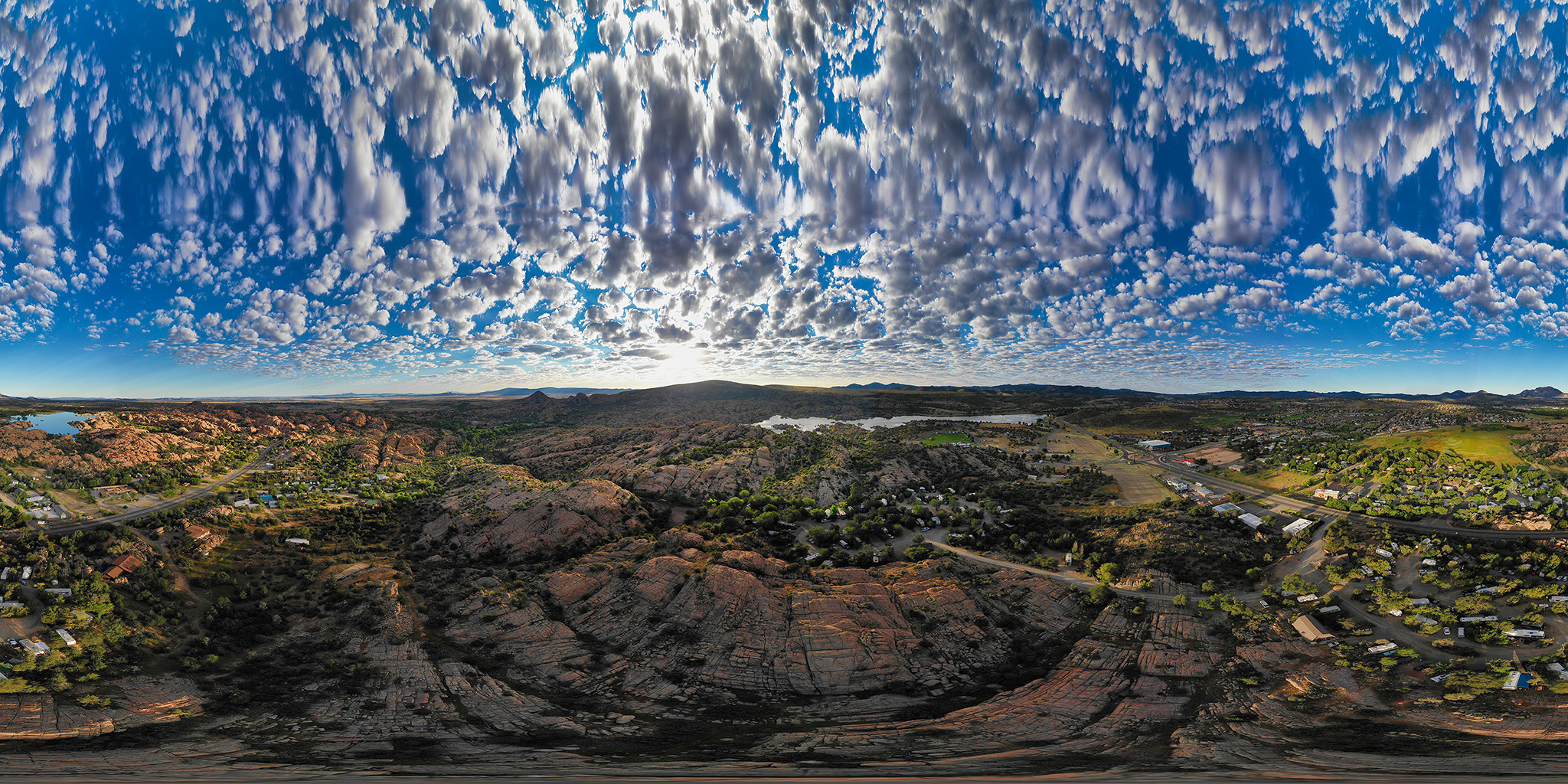
360 Degree Panoramics - They're not just for Facebook anymore
360 panos are all the rage on many Social Media platforms these days. Cute and eye catching, internet users eat them up. In a few months time they'll be replaced by something else, but for business purposes they're here to stay.
360 panos allow your website visitors to really get a birds eye view of your project / business. In the case of destination locations (RV Parks, B&Bs, Tourist attractions, etc) the 360 pano allows your online visitors the opportunity to see things from above. You can answer a great many questions about your business' surrounding area with a 360 panoramic. Just take at the one included in this section!
The sample panorama is an aerial view of the upper loop of Point of Rocks RV Park, one of our Prescott clients. You can zoom the pano in and out, and click your mouse along the pano to focus above and below. This allows potential guests to get a great view of the sites available to camp in. Additionally, you can open the pano to full screen with the button in the upper right corner of the pano.
Aerial Video
Video from the air can be amazing. It used to be you'd need a sizable budget to display your business from the air. Helicopter daily rental rates aren't cheap to be certain. But now with UAVs aerial video documentation breaking the budget is no longer an issue.
Whether you're looking for new marketing venues with online video about your company, or looking to take advantage of video time line progression reports, aerial video is within your reach.
For construction groups, aerial time lapse video can be invaluable. Scheduling a weekly, monthly, or quarterly fly over of your construction site you can quickly and easily see the progress of your current project. With the latest autonomous flight software AZ Drone can pre-plan a flight that covers the same sections of your project for the same length of time, combining regular videos into a full progression time lapse.
Beyond construction, aerial video is great for marketing purposes and outreach to new customers. Compelling terrestrial and aerial video can give you an advantage over you competition.
For more information about all that we do at AZ Drone please feel free to contact us!